Project Update
1/14/2026 RWSA’s contractor continues to concentrate their efforts on Stadium Drive. Upon completion, they will revert to working on Lewis Street. Crews may be observed collecting core and soil samples near the railroad tracks on Lewis Street and Avon Street. These core samples will provide essential information to construction crews in anticipation of boring beneath the railroad tracks. The schedule for the boring operation under the railroad tracks has not yet been established.
Background
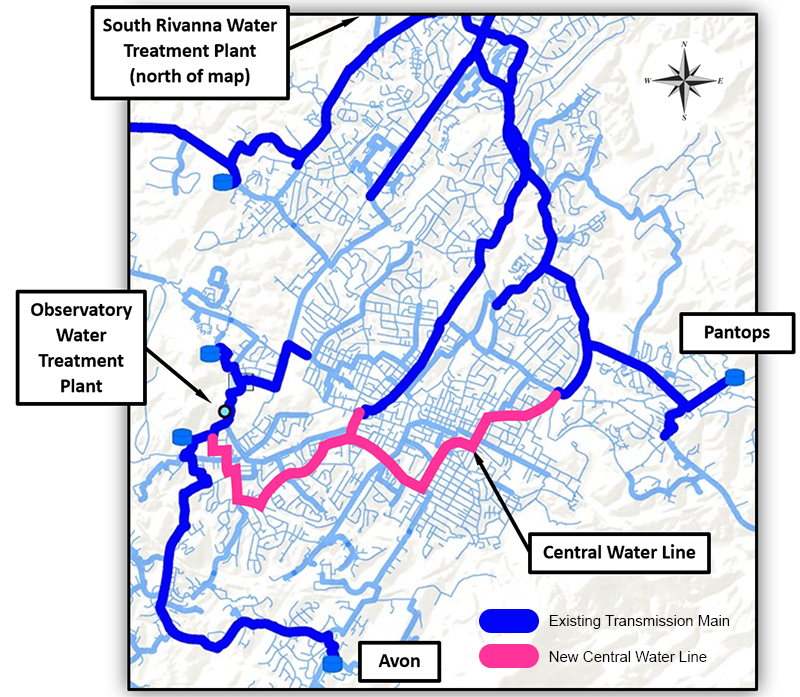
The Central Water Line Project will improve the Urban Area Drinking Water System by installing a finished water transmission pipe through the southern and central portions of Charlottesville. It is being constructed of 24-inch and 30-inch ductile iron pipes and span approximately five miles. The new finished water transmission pipe will connect transmission main pipes from both the South Rivanna Water Treatment Plant and Observatory Water Treatment Plant to enhance drinking water pressure and reduce outages due to pipe breaks. This project marks a significant endeavor that will provide immediate benefits upon completion for current and future generations.
System-Wide Water Infrastructure Upgrades
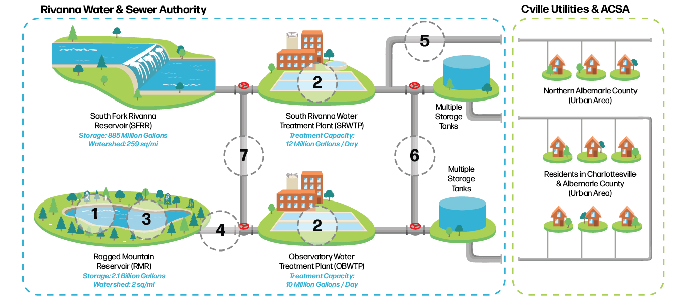
The Central Water Line is one of several projects currently under construction by RWSA. Over the next five years, RWSA will invest more than $300 million to enhance our urban raw water storage capabilities, raw water transmission pipelines, and transmission pipelines for finished water (treated drinking water). The purpose of these projects is to improve the capacity, redundancy, and resiliency of our drinking water systems. Doing so will help prevent unplanned outages and ensure residents have a constant, reliable, clean supply of water at their tap.

- New Earthen Dam – In 2014, RWSA completed building a new dam at the Ragged Mountain Reservoir. Watch a timelapse video of the project.
- Water Treatment Plant Improvements – Recent facility renovations and upgrades have increased treatment capacity.
- Ragged Mountain Reservoir Pool Fill Project – RWSA will fully utilize the reservoir’s storage capacity by adding 700 million gallons of water for a total capacity of 2.1 billion gallons.
- Ragged Mountain Reservoir to Observatory Water Treatment Plant Raw Water Line and Pump Station – A new 36” transmission pipe is replacing two smaller 70 and 100-year-old transmission pipes.
- South Rivanna River Crossing – A large 24” finished water transmission pipe is being added to better support the northern area in Albemarle County
- Central Water Line – The Central Water Line will provide a high-flow, large-diameter finished water transmission pipe that will better connect RWSA’s treatment facilities, transmission pipes, water storage tanks, and water distribution piping in the urban area.
- South Fork Rivanna Reservoir to Ragged Mountain Reservoir Raw Water Pipeline, Pump Station, and Intake – The new pipeline and pump station will allow RWSA to fully utilize the South Fork Rivanna Reservoir’s watershed and Ragged Mountain Reservoir’s storage capacity. It will also allow both water treatment plants to pull water from either reservoir.
Project Schedule
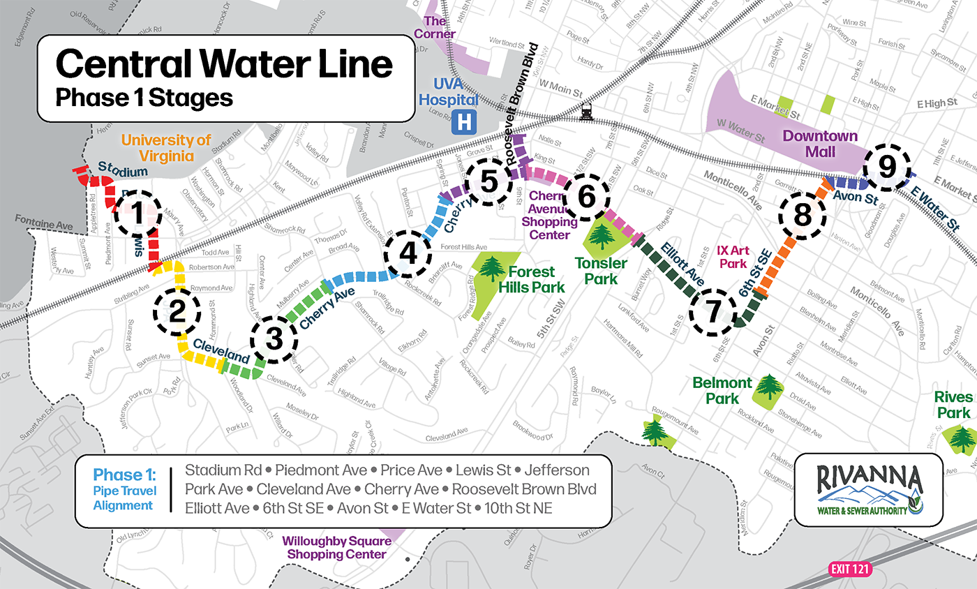
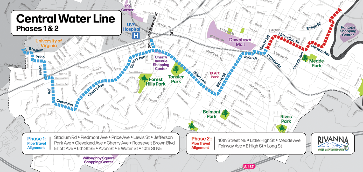
The project has been broken down into two phases with Phase 1 having nine stages. Sagres Construction is currently working on Phase 1, Stage 1 of the project. Completion of both phases is expected in 2029.

- Summer 2022: Complete survey and subsurface utility engineering
- Late Fall 2022 – Complete 30% Design Documents
- Winter/Spring 2022-2023 – Complete Geotechnical Work and 60% Design Documents
- Spring-Summer 2024 – Easement Acquisition and Permitting
- Fall 2024 – Complete 90% Design Documents
- Winter/Spring 2025 – Complete design and bid the project
- June 2025 – Award construction project to contractor
- Fall 2025 – Start Construction on Phase 1
- Stage 1 – Hereford Dr/Stadium Rd to Lewis St/Railroad (Map)
- October 2025 to February 2026 (work will start on Lewis St and work north towards UVA)
- Stage 2 – JPA/Railroad to Cleveland Ave/Woodland Dr (Map)
- January 2026 to August 2026
- Stage 3 – Cleveland Ave/Woodland Dr to Cherry Ave/Shamrock Rd (Map)
- July 2026 to January 2027
- Stage 4 – Cherry Ave/Shamrock Rd to Cherry Ave/Spring St (Map)
- December 2026 to July 2027
- Stage 5 – Cherry Ave/Spring St to Roosevelt Brown Blvd/Railroad (Map)
- June 2027 to October 2027
- Stage 6 – Cherry Ave/Roosevelt Brown Blvd to Elliott Ave/Ridge St (Map)
- October 2027 to December 2027
- Stage 7 – Elliott Ave/Ridge St to 6th St SE/Blenheim Ave (Map)
- December 2027 to April 2028
- Stage 8 – 6th St SE/Blenheim Ave to 6th St SE/Avon St (Map)
- March 2028 to July 2028
- Stage 9 – Avon St to 10th St NE/E Market St (Map)
- April 2028 to November 2028
- Stage 1 – Hereford Dr/Stadium Rd to Lewis St/Railroad (Map)
- Winter 2029 – Complete construction
Working Hours
General working hours will occur Monday through Friday from 7:00 AM to 6:00 PM. Some night work will be required at the Fontaine Ave & Lewis St intersection, Roosevelt Brown Blvd and Cherry Ave intersection, 5th St & Cherry Ave intersection, and 10th St NE & E Market St intersection. Weekend work may occur if approved in advance by RWSA.
Access
Access to businesses and private property will be provided at all times during the construction. Temporary steel plates will be on-site to facilitate vehicle travel. At the end of each week, temporary paving will occur in areas that have been disturbed. Crews will return within six months to complete the final paving. This last stage covers a wider section of roadway, often extending across the entire lane or street. This ensures that the street will have a smooth, durable, and long-lasting driving surface. If, for whatever reason, the temporary pavement deteriorates, the contractor will repair the pavement until the permanent paving is complete.
Communication Efforts
Upcoming February 11, 2026 – RWSA will attend the Fry’s Spring regularly scheduled neighborhood meeting to provide information about the project and answer any questions attendees may have.
December 19, 2025 – e-Newsletter was sent to subscribers. Information included details about upcoming construction efforts near UVA.
December 15, 2025 – A virtual meeting was held at 7:00 PM to discuss construction efforts in the Fry’s Spring and Johnson Village neighborhoods. You may download the slides or watch a recording of the presentation.
November 10, 2025 – Press Release: Night Work Planned for Fontaine Avenue
November 4, 2025 – e-Newsletter was sent to subscribers. Information included details about construction efforts on Lewis Street.
October 21, 2025 – A virtual meeting was held at 12:00 PM to discuss the construction efforts in the JPA neighborhood. Click here for to watch a recording of the presentation.
October 16, 2025 – Press Release: Central Water Line Project Set to Begin
September 16, 2025 – A Public Information Session took place at the Carver Recreation Center located at 233 4th St NW, Charlottesville, VA 22903. You may download the slides or watch a recording of the presentation.
September 10, 2025 – Press Release: Public Information Session for the Central Water Line Project
September, 3, 2025 – e-Newsletter was sent to subscribers
August 27, 2025 – Letters were mailed to property owners along both Phase 1 and Phase 2 of the Central Water Line route
June 2024 – An updated fact sheet was shared
June 2024 – Letters were mailed to property owners along Phase 2’s route
Spring 2022 – Letters were mailed to property owners along the proposed route
Central Water Alignment
In the spring of 2021, the Rivanna Water and Sewer Authority (RWSA), in partnership with its engineering consultant Michael Baker International (“Baker”), undertook a detailed routing study for a new central water line. This study was conducted in close coordination with the City of Charlottesville’s Utilities and Traffic Departments, as well as the Albemarle County Service Authority (ACSA). The purpose of the study was to assess multiple route alternatives for a major new water main intended to cross the heart of the City, with the goal of identifying the most feasible and minimally disruptive alignment.
The water line is expected to span approximately five miles and will include both 24-inch and 30-inch ductile iron pipe. Strategically designed to enhance the urban water system, the new line will link three critical RWSA transmission mains: the 24-inch Observatory Water Line located on the City’s western edge near the University of Virginia, the 24-inch Urban Water Line at the intersection of Roosevelt Brown Boulevard and Main Street, and the 18-inch Pantops Water Line near East High Street and Long Street. By interconnecting these key pipelines, the project aims to significantly improve system redundancy and operational flexibility.
The routing study took into account a wide range of considerations to ensure the selected path was both technically and logistically sound. Factors such as constructability, neighborhood and traffic impacts, access and easement requirements, permitting challenges, construction costs, railroad crossing logistics, coordination with ongoing or planned City infrastructure projects, and the density of underground utilities were all carefully evaluated. After a comprehensive analysis, the team identified a preferred route that follows the progression of Stadium Road, Piedmont Avenue, Price Avenue, Lewis Street (to the railroad), Jefferson Park Avenue, Cleveland Avenue, Cherry Avenue, Elliot Avenue, 6th Street SE, Avon Street (to the railroad), East Water Street, and 10th Street NE.
To keep the public informed and engage with those potentially affected, RWSA mailed letters in the spring of 2022 to property owners located along the proposed route.
Historical Context
In October 1987, the City of Charlottesville, the Albemarle County Service Authority (ACSA), and the Rivanna Water and Sewer Authority (RWSA) entered into the Southern Loop Agreement. This agreement established a two-phase plan aimed at enhancing the water transmission and storage system to improve connectivity and strengthen the urban water infrastructure. The first phase of the project included the construction of a two-million-gallon storage tank, known as the Avon Street Tank, located near Mill Creek Drive and Avon Street Extended. Additionally, a new 20-inch transmission main was built to connect the Avon Street Tank with the Observatory Water Treatment Plant (WTP), significantly improving water flow in the southern portion of the system.
Following the completion of the first phase, it became clear that while the Avon Street Tank was well connected to the Observatory WTP and the Pantops Tank was effectively linked to the South Rivanna WTP, overall system flexibility and hydraulic connectivity through the City were lacking. This limitation created operational inefficiencies. In 2017, a Request for Proposals was issued for professional engineering services to design and construct a new water main connecting the Avon Street and Pantops Tanks. This effort was intended to fulfill the second phase of the Southern Loop Water Line, commonly referred to as the “Avon to Pantops Water Line.” However, during the preliminary design phase in 2018, it was determined that the complexity of the water system required a more comprehensive approach, prompting a decision to pause the project and develop a Finished Water Master Plan.
The Finished Water Master Plan, initiated in August 2018, involved extensive data collection from RWSA, ACSA, the City, and the University of Virginia (UVa) and field testing. A calibrated hydraulic model was developed to reflect updated demand projections from the Urban Water Demand Project and Safe Yield Study, along with planned Capital Improvement Projects and ongoing upgrades to the Observatory and South Rivanna WTPs. Through a series of workshops with local utility stakeholders, the study concluded that constructing a central water line corridor through the City would best achieve the original goals of the Avon to Pantops Water Line. This solution offered enhanced hydraulic efficiency and operational flexibility for the entire urban water system.

With these findings in hand, the RWSA Board of Directors authorized a new work plan with Baker in June 2021 to advance the Central Water Line project. This included preliminary engineering, design, surveying, permitting, and community outreach. Coordination with local departments, including City Utilities, ACSA, UVa, and railroads, commenced, and survey notification letters were sent to affected property owners in November 2021. By June 2022, both the RWSA Board and the Charlottesville City Council had approved the design. In June 2025, Phase 1 of the Central Water Line project was awarded to Sagres Construction (Careers) in the amount of $47,450,000. This project represents a major investment in long-term water system reliability and resiliency for the City of Charlottesville and urban area in Albemarle County.
Past Updates
12/15/2025 RWSA’s contractor has shifted their focus from working on Lewis Street to the UVA property adjacent to Hereford Drive. Tree-clearing efforts have already taken place as the site is prepared for pipe installation. Crews will install a new 30″ pipe under Hereford Drive and Stadium Road in the coming weeks.
12/2/2025 RWSA’s contractor continues to install 30-inch ductile iron pipe on Lewis Street north of Fontaine Avenue. Initial flushing of a newly installed City water line is taking place on Lewis Street just south of Fontaine Avenue. Tree clearing efforts, erosion and soil control barriers, and test pits are occurring near Hereford Drive. Construction crews plan to install 30-inch ductile iron pipe on land adjacent to Hereford Drive starting on 12/9.
11/21/2025 RWSA’s contractor completed the Fontaine Avenue crossing this week. Daytime working hours have resumed, with paving activities planned for the week of November 24. Construction crews will continue installing 30-inch ductile iron pipe north on Lewis Street towards Price Avenue.
11/18/2025 Join us for a virtual meeting to learn more about the upcoming Central Water Line construction efforts scheduled to take place in the Fry’s Spring and Johnson Village neighborhoods. The virtual meeting will take place on Monday, December 15, 2025, at 7:00 PM. The meeting can be joined by visiting: https://zoom.us/j/96088803773. Can’t make the meeting? A recording will be made available after the event.
11/7/2025 RWSA’s contractor is currently working on Phase 1, Stage 1 of the Central Water Line Project. Construction activities are occurring in the vicinity of Lewis Street, Fontaine Avenue, and Price Street. Starting Sunday, November 16, night work will begin at the Lewis Street & Fontaine Avenue intersection. Work hours will be from 8 PM to 5 AM. Temporary lane closures with flagging operations will be in effect. The night work is expected to last four nights but may extend due to potential unplanned weather interruptions. Once the intersection work is complete, construction activities will revert to regular daytime hours.
11/3/2025 RWSA’s contractor is currently working on Phase 1, Stage 1 of the Central Water Line Project. The first section of 30-inch pipe was installed on Monday, October 27, and by the end of the week, crews had successfully laid 120 feet of new pipe as they worked toward the intersection of Lewis Street and Fontaine Avenue. Construction efforts will continue this week as crews continue to install the 30-inch ductile iron pipe on Lewis Street. Focus will shift midweek to working on a 2-inch City water line also located on Lewis Street. By the end of the week, workers will begin sawcutting sections of road on Price Street. The contractor hopes to begin installing pipe across Fontaine Avenue at the Lewis Street intersection next week (11/10). Construction at the intersection will occur at night to minimize traffic impacts.
10/22/2025 RWSA’s contractor has begun staging materials and equipment at the southern end of Lewis Street. Saw cutting of the pavement has begun. Pipe installation is scheduled to start on Monday, October 27, 2025. Construction will begin near the railroad tracks and progress north along Lewis Street. The contractor plans to use a convoy method to excavate dirt, lay pipe, and then backfill. All equipment will work in a single file line with excavators and dump trucks positioned at either end of the construction zone. This method will help maintain access to businesses and residences. Localized detours are expected. Some nighttime work will occur at the Fontaine Avenue and Lewis Street intersection.
Contact Us
For general questions, please send an email to CentralWaterLine@Rivanna.org. For safety related issues or time-sensitive concerns please call 434-977-2970.

